This website has been set up as part of a community education project which allows YOU to follow the movements of Wallu, the first ever Wedge-tailed Eagle to be satellite tracked, and other eagles subsequently satellite-tagged in Western Australia. This exciting and pioneering study, which now forms part of Simon Cherriman's PhD project, aims to shed light on aspects of a unique Australian eagles' ecology which have never before been researched.
Tuesday, 13 June 2017
Long Distance Flyers
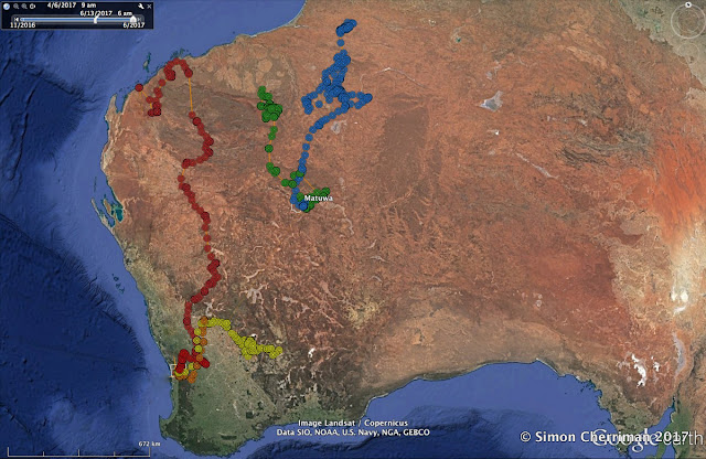
We know from research conducted by CSIRO in the in 1960's and 1970's that Wedge-tailed Eagles are capable of making long-distance movements of several hundred kilometres, but this important work was carried out during a time when banding/ringing was the only method available. The recovery rate of banded birds is usually very low (perhaps less than 10 percent), and the path flown between banding and recovery sites is not able to be determined. The satellite-tracking methods used in modern research, however, gives much more detail on eagle movement, and it’s been extremely exciting to follow the journeys of juvenile eagles satellite-tagged last year. The above map shows the movement paths of 4 birds from the Perth Hills: Walyunga (who made it all the way to the Pilbara) in pale red, Kala in yellow, Korung in orange, and Yirrabiddi (who only left her natal territory last week) in deeper red. It also shows in blue the northward journey of Malya, who moved 750 km north of Matuwa during dispersal.
The fifth bird, shown in green, is Kuyurnpa, the first juvenile eagle to be tracked using a GPS/Satellite transmitter, being fitted with this device in 2013. She is now nearly 4 years old, and has continued to move very long distances like those we detected in her early dispersal phase several years ago, frequently travelling the ~400 km between the Fortescue Marsh area and the expansive salt lake system of Lake Carnegie. It is clear from these maps that wedgies can certainly fly!, and Also of interest is the apparent pattern that birds seem to prefer going north - possibly due to cyclonic rainfall activity leading to ample food supply, conditions that may well attract young eagles. More insights about their habitat use at the landscape scale will be revealed as our tracking continues!
Subscribe to:
Post Comments (Atom)

No comments:
Post a Comment
Note: only a member of this blog may post a comment.